New Silk Roads - Asia Bazdyrieva and Solveig Suess - The Future Forecast

The Future Forecast

Asia Bazdyrieva and Solveig Suess

Framework of the big Earth data project (CASEarth). All images: Geocinema.

New Silk Roads
February 2020

The 3rd Digital Belt and Road conference was held in Tengchong, southern China, in early December, 2018. Initiated by the Chinese Academy of Science, it was a space to share expertise, technologies, and best data practices between representatives from across the world, demonstrating the significance of Earth observation for sustainable development. The Digital Belt and Road was framed as more than just a science and technology conference, but as a way to understand the world. Under the mandate to study past climates towards future protection, its networks were claimed to form an umbrella to support the ever-more fluid international exchange of data and information.1

Similar to the Belt and Road Initiative, the geographies of its digital counterpart remain not clearly defined yet ever expanding. Having twenty-seven satellite missions, super computers in Jinan and Wuxi, and four satellite ground stations within China’s borders, the initiative had already launched eight representative centers outside and across four continents before the end of 2018; first in Bangkok, then Helsinki, Potenza, El Jadida, Peshawar, Moscow, New York, and Lusaka, with many more to come. Made of an ensemble of coordinates, the project relies on creating networks between nation-states with more than sixty regional partnerships and transnational agencies such as the United Nations. Less explicit is how these locations coincide with particular infrastructural partnerships, where along with “capacity building” for scientific exchange, heavy projects laying down fiber-optic cables have been enabled across regions in Eurasia, Africa, and the Arctic.2 This includes the Lusaka economic zone, a China Smart Tech City in Morocco, with similar contracts in Thailand, Pakistan, and a 10,500 km fiber-optic link across the polar seabed through Russia into Finland.3

Attending the conference inside the luxurious Grand Empark Hotel as spectators, we shared an impromptu meal with Alexandre Caldas, a representative from the UN Environment Program. With a team of dancers brushing around in the background entertaining guests, switching between ethnic costumes and dancing motifs while maintaining food and drinks in a generous equilibrium, Caldas spoke of the general consensus that the promise of a stable legal order established by the united international cooperation of nations following the two World Wars had been in stagnation for a while now. As we finish eating, he sketched out a series of simple graphs in a conference notebook, narrating for us scenes of possible futures. “We have now entered,” he told us, “the unstable transitional period that might take two to three decades before the new geopolitical order is established.” The parallel crises of western democracy and ongoing global ecological turmoil convinced him that this new order is not only inevitable, but already underway through initiatives such as the Belt and Road.

These were sentiments clearly not limited to the UN representative, but shared by an array of actors such as scientists, researchers, and representatives of the European commission who were present for the two-day conference to seek new forms of cooperation. At the conference’s ceremonies and speeches, the international community in attendance cheered to the shared enthusiasm of technological promises to battle climate change with Big Data. Potential partners lined up to pitch their agendas with attempts to join this ever-expanding network. The initiative aims to eventually be instrumental in managing disasters and other risks, where markets, populations, and climates can be algorithmically calculable and mappable as the nearest future forecast.

Caldas left us at the table on the note that these processes of redistributing global powers will not be “visible,” so to say. Current attempts to expand spheres of sociopolitical and economic influence no longer demand invasions through military force. Instead, these processes operate through the seemingly invisible and not-necessarily territorial. Many of the projects proposed over the duration of the conference included ways to accrue sets of data from “developing countries”— nation-states which did not have the capacity for their own satellite ground stations or supercomputers. Bangladesh and Myanmar were promised on-demand satellite images of their own territories through an online gateway. Funding provided by the Chinese state was to allow the UN Environment Program to implement air and water monitoring systems in Nairobi, Cape Town, in Addis Ababa. Yet, contrary to our dinner conversation, these “invisible” processes visualize themselves differently on various temporal and spatial scales.

The shift in understanding of the concept of Digital Earth.

Digital Earths

The project of the Digital Belt and Road (DBAR) was born out of the Chinese Science Academy, with its operations based in the newly-built campus of the Institute of Remote Sensing and Digital Earth in Beijing. A massive cinema theater that resembles the globe lies at its center, pivoting separate departments and buildings around it. While on a visit to its campus a few months prior to the conference, we entered the cinema globe to find it empty and idle, projectors humming steadily in anticipation of the film that was about to be shown. Wearing 3D glasses, we were immersed in a short film that was led by a bombastic American narrator who outlined humanity’s main challenges with climate change and posited DBAR as solution to these problems.

The technocratic imagination of the film projected inside of the cinema-globe folded in a series of political environmental rhetorics which emerged alongside China’s integration into global information capitalism. In 1996, Chinese economist, speechwriter, and economic advisor of Prime Minister Deng Xiaoping, Yu Guangyuan wrote a seminal text entitled “The Smallness of the Earth and the Largeness of the Earth,” in which he proposed the “grand exploitation of the earth along with its grand protection.”4 The “smallness” of the earth in Yu’s argument alluded to popular environmental concerns of its time, according to which the earth was to be protected, for the survival of humankind depended on it. As for the “largeness of the earth,” Yu pointed out the many resources on the earth that have not yet been exploited, and that the success of that exploitation “depends on our calculation and speculation on its profitability.”

Still from 3D film about Digital Earth Chinese Science Academy, Beijing.

Over the decades of Deng Xiaoping’s planned economy and market reforms, Yu developed this environmental rhetoric, binding production and ecology together by framing environmental protection as a form of productive labor. Fresh air and clean water have, in this sense, become products of labor, where quantitatively calculating the positive and negative effects of industry can inform future decisions in making better use of labor in damaged environments.5 Within this line of thinking, high levels of pollution can, for example, dictate the expulsion of heavy industries out of a city’s periphery, and millions of laborers can be sent to plant forests battling growing deserts. What such labor brings can be calculated to benefit the economy, whereby fixing these damages and industrial after-effects can further stimulate the movement of capital and labor. Yu’s vision had presented the earth as a holistic image while being an object of scientific construction. It was a logic of governance claiming that, if accurately calculated, the entirety of the planet can be exploited, and its negative effects reverse-engineered through further labor.

After we watched the film, we met with Professor Li who was head of DBAR’s Big Data working group. He introduced their methodology, which we quickly learned was developed in consultation with former US vice president, Al Gore. The name of the Institute was directly inspired by Gore’s 1998 speech in which he made a claim for a “‘Digital Earth’: a multi-resolution, three-dimensional virtual representation of the planet into which vast quantities of geo-referenced data can be embedded.”6 Li continued describing to us how many contemporary problems surrounding the climate crisis can be summed up as being issues of communication: communication of scientific knowledge around how the earth is changing; between “facts” and our understanding; and structurally, the communication between technical providers and decision makers, with the growing need for bureaucratic departments being able to communicate with each other. “Digital Earth is another way to understand the world. Everything can be changed into data, to simulate precisely and to try and understand what the problems are that our society faces.”7

The cinema theater at the campus of The Institute for Remote Sensing and Digital Earth Chinese Science Academy, Beijing.

Throughout Li’s explication of the Digital Belt and Road, close alignment with the United Nations and collaborating to meet the UN’s sustainable development goals (SDGs), which seeks to address problems exceeding national borders such as air pollution and water security and quality, was emphasized.8 Figurations of Yu’s concepts of “smallness” and “largeness” were present throughout our conversations with professor Li, now paired harmoniously with the United Nations’ measurable, calculable, and “sustainable development.” Taking science as a lead, both ideas encourage continuously proposing technologically-innovative yet market-conforming solutions, further depoliticizing the ecological crisis.9 This techno-political hybrid has taken shape with the trusted guidance of technocrats and scientists, reinforcing what T.J. Demos refers to as the “techno-utopian position that ‘we’ have indeed mastered nature, just as we have mastered its imaging—and in fact the two, the dual colonization of nature and representation, appear inextricably intertwined.”10

The Laboratory

Forty-nine years prior to the 3rd Digital Belt and Road Conference, remote imagery was first put to use in Tengchong. It was the first time Chinese scientists operationalized cosmic data from US Landsat satellites. The area was amongst a few chosen by the Chinese Communist Party to be test zones, tasked with developing a set of ground truths and collating a spectrum of objects that can be used for further quantitative and qualitative research. As part of the airborne remote-sensing experiment, 15,000 rock, soil, vegetation, and water samples were taken from Tengchong’s mountainous landscapes and folded into a database that included their unique spectral signatures, as seen from above.11 These standardized object-sets became key for satellites to accurately see into the earth’s crust across Chinese territories, and were developed in parallel to China’s own remote-sensing system. New forms of optical media such as 9-band sensors or RMK-A aerial cameras allowed for data to be scanned and translated into infrared photography, making visible not only the spectral signatures of minerals, petroleum, and coal resources, but also of pollution from urban and oceanic topographies.

It was also during these years, within the laboratories of the Chinese Science Academy, that married chemists Gao Xiaoxia and Xu Guangxian distilled a process of separating ten components of rare earth elements. Gao Xiaoxia developed the instruments, tools, and methods to analyze trace amounts of chemical substances, while Xu Guangxian developed the theory of countercurrent extraction. What had crystallized in their moment of synthesis was a way to dramatically reduce the time and costs needed to extract rare earth minerals, catalyzing China into an industrial revolution.

Ground truth representations, each element is representing a real world object.

In the late 1970s, the then-new Prime Minister Deng Xiaoping rerouted scientific and technological ambitions away from defense and towards the economy with the ambition of integrating China into the global market. Within this context, Xu Guangxian, who had previously worked in the state’s nuclear program, applied his research into the extraction of uranium isotopes towards the newer interest in rare earths. During the 1980s, Deng Xiaoping launched program 863, which took biotechnology, aerospace, aviation, electronics, automation, and energy as its focus, seeking to detach China from its dependence on foreign technologies. Each of its departments demanded a high concentration of all seventeen kinds of rare earth minerals. The aerospace technology department, for example, embedded rare earth minerals in satellite sensors and coordination systems.

It is no coincidence that within the Gansu Province of Inner Mongolia, where cities like Baotou or Baiyun’ebo are amongst the largest dedicated to rare earth mining, sits the Jiuquan test zone, where missile and satellite launches are conducted over 300 days each year. Evident of Jussi Parikka’s observation that there’s a double bind “between knowing about the earth and the earth allowing that knowing to happen,”12 agendas of designing networks of sensors seeing into the earth’s crust was twinned by an outward extraterrestrial exploration looking back into itself. Where to extract, one needs to go up into space, and in order to go up, one must go down to build more satellite apparatuses out from extraction. Sean Cubitt refers to “geomedia” as an assemblage of earth-mediating operations that place time and value on a relational axis.13 Geomedia not only draws representations of moving lands and atmospheres, but predisposes certain ways of environments to form, and others to dissipate. Here, rare earth elements shift from solid mineral into liquid, digital circuits. Satellite images of territories feedback into their own transformation, with its cyclical loop perpetuated from the laborers who mine the minerals to the machines which transmit its reflective signatures.

The visualizing of land and air coincides with broader geopolitical events, where together they can be seen as redrawing much of the world’s organizational logics. By the early 1990s, with the immense production and export of China’s minerals, the price of rare earths on the global market had dropped to nearly one-quarter. Japan, France, and other nation states who previously held monopolies on the market were forced to implement production cuts, some even falling into bankruptcy.14 With europium (铕) emitting intense beams of red light from TV screens, yttrium (钇) being used in camera lenses, and mobile phones containing neodymium (钕), contemporary geopolitics are still defined by rare earth elements. Yet, following Jennifer Gabrys, “sensor-based technologies are not only environmentally located; they also inform and ‘program’ environments, have environmental impacts, and take hold in particular environments, whether for managing or monitoring processes.”15 The Digital Belt and Road is no exception, acting as enablers of grand infrastructural projects, through and from within geomedia, with “data-poor” countries as prime frontiers.

Coverage map of remote sensing satellite receiving station network along the New Silk Road in Asia, Africa, and Europe.

Measuring Progress

The UN Environment and Development Programs have partnered with DBAR to provide high-frequency satellite data supporting disaster risk reduction in zones such as the Pacific, along with funding projects related to issues of air and water quality degradation in Africa. With the UN benefiting from Chinese state funding, the implementation of projects in Nairobi, Cape Town, and Addis Ababa include installing water and air sampling instruments, standardizing data acquisition and interpretation methods, and dispatching trained personnel to teach, read, and record them. Digital records taken in rapidly growing cities in Africa are sought by the Chinese state with the intent to use their datasets to inform better planning of cities which have grown just as explosively inside China. Failure to evaluate the environmental impacts of large-scale infrastructure projects like Eastern Economic Corridor in Thailand has also nudged local governments to seek further cooperation with DBAR.16

Despite dominant rhetorics, prior to being used within scientific research, the datasets accrued from DBAR’s distributed sensing technologies are first instrumentalized by the private sector.17 Clients here range from insurance companies to real estate developers, and those constructing projects such as ports, railways, or economic corridors. With the underlying claim that further ecological certainty will be possible from the harvest and interpretation of datasets from atmospheric particles, “big data” becomes a mode of sociopolitical and economic ordering. These migrating modes of governance are trained along “mining of implicit and non-obvious patterns, rules, and knowledge behind big data” made possible with financial promises and more practically through to standardization of scientific protocols.18 Numbers here hold more value the longer the duration of “controlled” figures have been accumulated, with the trustworthiness of nation-states granted through the reliability of datasets. Translating these datasets into possibility curves, statistical future projections, and graduated maps, environmental risks are spoken into the vocabulary of GDP, political negotiations, and urban management.

With Earth Observation data annexed to capital, techniques of measurement are inseparable from infrastructures of governance, where interpretations of how the earth is changing are feeding back into political modeling across the Belt and Road. The current DBAR project pushes forth the functioning of “a digital nervous system of the globe, actively informing about events happening on (or close to) the Earth’s surface by connecting to sensor networks and situation-aware systems,” with “interoperable models and types of management and governance” to come.19 Dealing with massive amounts of Earth observation data, which requires constant maintenance of transferring, storing, processing and sharing geospatial data, being stressed throughout DBAR’s conferences and activities was developing and educating both a theory and method for interpreting Big Earth Data. It is here where power to make value and power over knowledge collude on unprecedented scales.20 With “data-poor” countries framed as new markets ripe with untapped data resources, development potential is seen not only through financial instruments but also by way of computational infrastructures, where the ownership of and control over hardware and software grants disproportionate governability.

3rd Digital Belt and Road conference Tengchong.

Epilogue

A digital earth is a spectacular thought. Its distributed networks are less holistic than the imaginations conjured through rhetoric. The earth’s nervous system is not a totality, but rather one articulation speaking through a distinctly technological, ideological, and geopolitical vantage. The figuration of earth as a measurable and a calculable entity allows for a form of techno-scientific governance to take hold, inspired by the balancing act of extraction and ecological repair alongside a universal scale of quantifiable progress. As a single image, this form of “knowing” the earth is ungraspable.

The optics of this vastly distributed and largely dumb apparatus brings forth a predominantly algorithmic language in observing land, simultaneously reading the earth’s surface as potent with futures while programming them towards pre-defined ends. Through the metronome of global markets, what becomes embedded in this apparatus is a form of governance which exceeds the boundaries of nation-states. Geometries of power over the future are being created in the present as datasets are accrued from geological formations, natural disasters, social media behaviors, and citizen biometrics alike. Its physical and virtual operations form only part of the larger socio-technical assemblage that is deeply intertwined with international financial instruments, investment schemes, and the construction of future cities. Moments of social and aesthetic instability point towards the closing down and opening up of politics; marking possible entry-points for redrawing relations.

Notes
1

See Digital Belt and Road, “The 3rd Digital Belt and Road Conference: Programme,” November 27, 2018, http://ddl.escience.cn/f/Rwks.

2

See Markku Kulmala et al., “Introduction: The Pan-Eurasian Experiment (PEEX)—multidisciplinary, multiscale and multicomponent research and capacity-building initiative,” Atmospheric Chemistry and Physics 15, no. 22 (November 2015).

3

Ting Shi, “10,000 Kilometers of Fiber-Optic Cable Show China’s Interest in Warming Arctic,” Bloomberg, December 13, 2017, .

4

Yu Guangyuan, “The Smallness of the Earth and the Largeness of the Earth—A Grand Idea on 21st Century Construction (1996),” in A Philosophical School is Rising in China (Nanchang: Jiangxi Science and Technology Press, 1996).

5

Yu Guanquan, “The environment should be quantitatively measured,” in Chinese Economists on Economic ReformCollected Works of Yu Guangyuan, ed. China Development Research Foundation (New York: Routledge, 2014) 64–68.

6

Al Gore, “The Digital Earth: Understanding our planet in the 21st Century,” The Australian Surveyor 43, no. 2 (June 1998): 89.

7

Ibid.

8

“Background,” Digital Belt and Road, n.d., .

9

See Erik Swyngedouw “Trouble with Nature ‘Ecology as the New Opium for the Masses’” (PowerPoint presentation, The Second Meeting of the Human-Nature Platform, Lausanne, July 1, 2013), .

10

T. J. Demos, Against the Anthropocene. Visual Culture and Environment Today (Sternberg Press: 2017) 28.

11

Wen-Rui Hu ed., Space Science in China (Amsterdam: Overseas Publishers Association, 1997) 208–212.

12

We thank Jussi Parikka for his generosity in many conversations that we have had during this research under the Digital Earth fellowship. Jussi Parikka, Solveig Suess, Asia Bazdyrieva “Geocinema in conversation with Jussi Parikka,” July 17, 2019, in Digital Earth, podcast, MP3 audio, 43:32, .

13

Sean Cubitt, “Three Geomedia,” Ctrl-Z: New Media Philosophy 7 (May 2017), .

14

Ibid.

15

Jennifer Gabrys, Program Earth: Environmental Sensing Technology and the Making of a Computational Planet (Minneapolis: University of Minnesota Press, 2016), vii.

16

We thank Dr. Monthip Sriratana, the Director of the Digital Belt and Road International Centre of Excellence (ICoE Bangkok) and the Director of Climate Change Research Strategy Center of the National Research Council of Thailand, for generous welcoming and conversation during our research in Thailand.

17

Ibid.

18

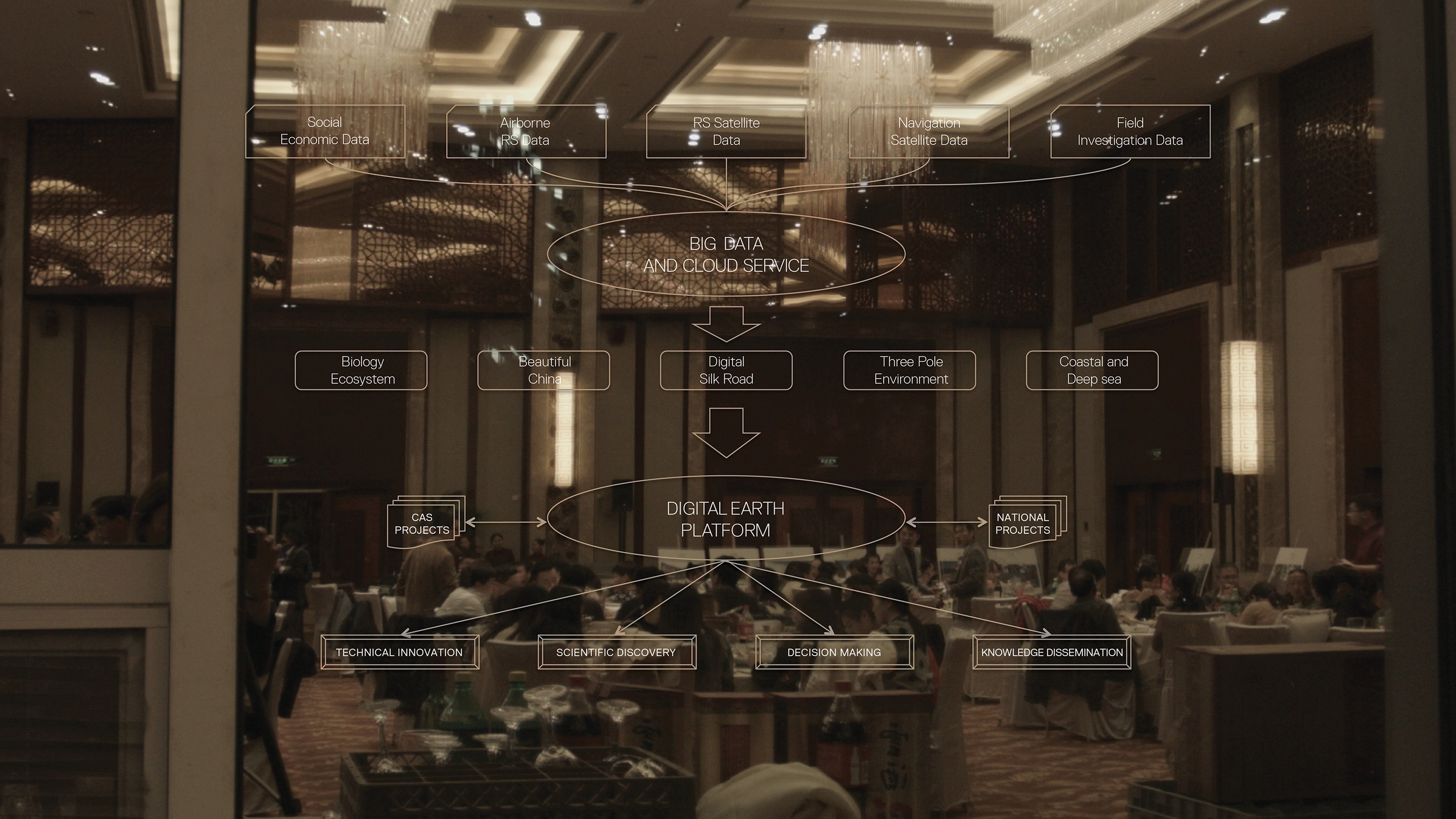
Huadong Guo et al., “Big Earth Data: a new challenge and opportunity for Digital Earth’s development,” International Journal of Digital Earth 10 (November 2017): 1–12.

19

Michael F. Goodchild et al., “Next-generation Digital Earth,” Proceedings of the National Academy of Sciences 109, no. 28 (June 2012): 11,092.

20

Nick Couldry and Ulises A. Mejias, The Costs of Connection: How Data Is Colonizing Human Life and Appropriating It for Capitalism (Stanford: Stanford University Press, 2019), xii.

New Silk Roads is a collaboration between Aformal Academy and e-flux Architecture. The project has been supported by Design Trust, and has been produced in cooperation with Digital Earth.

Category
Data & Information, Globalization
Subject
China, Climate change, Extractivism, Pollution & Toxicity
Return to New Silk Roads

Asia Bazdyrieva is an art historian whose work focuses on hybrid European-Soviet modernity and its ideological and material implications in spaces, bodies, and lands. Bazdyrieva co-authored Geocinema, a collaborative project exploring infrastructures of earth sensing as a form of cinema, which has been nominated for the Schering Stiftung Award for Artistic Research (2020) and the Golden Key Prize at the Kassel Dokfest (2021). She is currently an associative member of Critical Media Lab Basel and a resident of transmediale.

Solveig Suess completed her undergraduate in Visual Communication at the Glasgow School of Art, and her postgraduate at the Centre for Research Architecture, Goldsmiths University, London. Together with Asia Bazdyrieva, they form “Geocinema,” a project that examines infrastructures of earth-sensing data as forms of cinema. Solveig is a 2018–2019 Digital Earth fellow.

Advertisement
Subscribe

e-flux announcements are emailed press releases for art exhibitions from all over the world.

Agenda delivers news from galleries, art spaces, and publications, while Criticism publishes reviews of exhibitions and books.

Architecture announcements cover current architecture and design projects, symposia, exhibitions, and publications from all over the world.

Film announcements are newsletters about screenings, film festivals, and exhibitions of moving image.

Education announces academic employment opportunities, calls for applications, symposia, publications, exhibitions, and educational programs.

Sign up to receive information about events organized by e-flux at e-flux Screening Room, Bar Laika, or elsewhere.

I have read e-flux’s privacy policy and agree that e-flux may send me announcements to the email address entered above and that my data will be processed for this purpose in accordance with e-flux’s privacy policy*

Thank you for your interest in e-flux. Check your inbox to confirm your subscription.