Issue #101 Meta-geography and the Navigation of Space

Meta-geography and the Navigation of Space

Nikolay Smirnov

Issue #101
June 2019

Human beings perceive space through its reflection in their own consciousness and corporeal perception; space, spatial images, and their representations determine and define one another. The foundational principle of the practice of meta-geography is the understanding that changing space or its image/imago, or the representations of the latter, means changing life—and vice versa.1 A shift in one of the three components will inevitably trigger a shift in the others. Meta-geography offers a new perspective on geography that champions the interdependence of any given space, its images/imagoes, and its representations. In other words, geographical constructs do not only depend on the spaces they represent; those spaces themselves are formed in accordance with our representations of them.

According to Russian geographer Dmitry Zamyatin, meta-geography can be understood as “images of space and [the] space of images.”2 The word “image” here literally designates the Russian word образ, which signifies not only visual representation, but also cognitive, linguistic, aural, or bodily forms of representation. It is closer to the understanding of the image in the practice of Russian icon painting, or the depiction of the creative work of imagination in the writings of Henry Corbin or Gilbert Durand.3 In this sense, the image is indissolubly connected to thought and space. Spatial imagination is intimately linked to the human mind and its projective activity.

The twentieth century initiated a process of “shattering” the nation-state space, and of imagining the creation of “other” spaces. Many spatial practices that emerged in Russia starting in the 1960s—such as those of Soviet geographer Boris Rodoman, discussed below—aimed at destroying the invisible walls established by streams of “power.” Moreover, these activities sought to create spaces of alternative experience.

In a meta-geographical interpretation of the world, the phenomenological becomes ontological precisely via imagination. In other words, meta-geography focuses on phenomenological and ontological aspects of the “space of images.” This approach asserts that it is a fundamentally impossible to cognize the world outside of human perception and imagination, which means that all geographical knowledge takes the form of images.4

Meta-geography is a specific branch of critical geography developed in Soviet and post-Soviet Russia. Taken together, the various phases of meta-geography that have evolved since the 1960s constitute a framework encompassing both a critical reflection on mapping—from the state and geopolitical level right down to the deepest personal level—as well as a counter-mapping practice that actively involves both thinking and corporality.

The related practices of diagrammatics, cognitive mapping, and counter-mapping lead us to the core of the concept of meta-geography, which connects landscape, mind, and body in a single research assemblage. The knowledge and practices developed by successive generations of Soviet thinkers and scientists allow us today to understand meta-geography as a tool for navigation by way of “rewriting” and constructing spaces.

Boris Rodoman, “Polarized Biosphere,” c. 1970-1Paper, mixed media, 132 × 168 cm. Translated by Nikolay Smirnov. Copyright: Boris Rodoman, Museum of Russian Geographical Society. 

I. The Birth of Meta-geography: The Soviet Period and Boris Rodoman

In the Soviet Union, meta-geographical concepts were originally explored by proponents of mathematical modeling in geography. The term “meta-geography” was probably first proposed by geographer Yulian Saushkin in the late 1960s, amidst a general interest in metascience, or “science about science,” and following the example of “meta-cartography” in particular.5 In 1967, Soviet geographers Veniamin Gokhman, Boris Gurevich, and Yulian Saushkin presented a paper on the basic principles of meta-geography at the seventh congress of the Regional Science Association International at The Hague.6 In their view, meta-geography was a theoretical discipline that tries to identify patterns according to which geographical knowledge is formed. The meta-science “explores the potential and the possibilities of geographical science by bringing out its fundamental nature,” and describes basic geographical notions such as “space.”7

Meta-geography was quickly assimilated into theoretical geography—that is, the area of knowledge that studies and constructs theoretical models such as models of the evolution of metropolitan areas. With varying degrees of accuracy, such models can visually and mathematically express a process that takes place in the geosphere.

In the 1960s, geographer Boris Rodoman, a young colleague of Saushkin, first conceived of “geo-cartoids.” According to Rodoman, “Geographical cartoids (or geo-cartoids) are diagrams depicting a real or imaginary territory more simply, without necessarily complying with the rules of classical cartography—for instance, without projection or scaling, and with exaggeratedly straightened lines and coarse outlines.”8 By way of example, Rodoman proposed that the cartographic drawings made by prehistoric hunters, warriors, shepherds, and treasure hunters could all be considered cartoids, and that certain medieval world maps, along with cartographic drawings on contemporary posters, flags, badges, labels, and book covers, fit into the same category.

Because they are more generalized than maps, cartoids are very useful for depicting typical, imaginative, and ideal territorial models. That’s why Rodoman considered cartoids to be the building blocks of the language of theoretical geography. He traced their function as representations of abstract geographical models in science back to the nineteenth century—for example, in the graphical representation of Johann Heinrich von Thünen’s Model of Land Use” (1826). But it is only in the second half of 1960s that cartoids were implemented as the main method of theoretical geography. Rodoman claims that they actually generated, rather than served, the discipline.9

In Rodoman’s map-like diagrams we are confronted not only with the features of the objects being mapped (a landscape, the author’s experience, or his interests), but also with the mapping procedure itself as a fundamentally important and basic feature of the human mind. The common link between a cartoid that depicts a model of a landscape and a cartoid that schematizes the interests of its author reveals the very procedure of mapping as primarily a cognitive process. Moreover, by charting and mapping himself and his own interests, the researcher makes visible the processes of constructing the subject. In other words, through his geo-cartoids, Rodoman reveals the action of forces and flows of power that construct the subject in many respects as a random assemblage.

The best known of the several dozen cartoids that Rodoman created is “Polarized Biosphere,” also known a “A Networked Polarized Landscape.” Rodoman argued that it

shows the desired combination of natural landscape and built environment, with conflicts reduced to a minimum. The city and wildlife are considered as two poles of the biosphere that man equally needs. They are divided by intermediary zones, with the degree of urbanization, intensity of economic activity, and population density increasing from the natural pole to the urban one.10

In Rodoman’s depiction, the various functional zones of this “polarized landscape” are located on an infinite plain, with no water. All cities on this cartoid appear to be the same size, making it a very abstract model. The forms of this basic cartoid could be transformed during the process of accounting for the real physical conditions of different geographical terrains. Accordingly, Rodoman explains that the lower part of the cartoid

shows the result of the first of the possible transformations of a basic cartoid—some water is introduced (a sea or lake), and this radically changes the entire configuration. It will change even more if we introduce rivers, mountains, etc. This is how we can move from an imaginary terrain to a real one.11

On the one hand, this cartoid/model is “idealized,” meaning that it “expresses a desired condition of the biosphere (the harmonic symbiosis of urban life and the natural environment).”12 On the other, Rodoman claims that his cartoids “reflect the specificity of our Russian space … of our cultural landscape … about which my disciple Vladimir Kagansky said the following: ‘The Russian landscape is the product of the interaction not between nature and society, but between nature and the state.’”13

According to Rodoman, the main features of the Russian landscape are: 1) its hyper-centralization, which reflects Russia’s bureaucratic hierarchy; 2) its radial spatial links, which are much more developed than its tangential links, so that the link between two neighboring cities is often weaker than their individual links to the administrative center (either the regional center or Moscow); and 3) this leads to a phenomenon called “the inner periphery,” where territories on the borders between administrative zones (areas that are the farthest from administrative centers) are the most undeveloped. That’s why these administrative dead ends so easily accommodate natural reserves. Observing this pattern, Rodoman formulated the “principle of the polarized landscape” and proposed to use this principle to realize a harmonious symbiosis between human and nature, as depicted in “Polarized Biosphere.”

Boris Rodoman, “Geo-bionics: City’s Ships and City’s Trees,” 1971. Left: Rodoman’s report announcement. Top right: underground development of cities, similar to the evolution of vegetation cover (bottom right). Translated by Nikolay Smirnov. Copyright: Boris Rodoman.

During his life, Rodoman produced many different variants of this specific cartoid. For a 1971 public address entitled “Polarized Biosphere and the City of the Future: Some Ways to Preserve the Natural Landscape during Urbanization” (delivered at the Moscow branch of the Geographical Society of the USSR), he drew cities as huge ships sailing in the lithosphere, the outermost layer of the earth’s crust. In this drawing, urban elements appear biological and organ-like. For example, telecommunication lines, designated in red, are not completely straight, instead resembling dendrites, which grow from a neuron core (in this metaphor: the urban center). In general, the space depicted in this model looks like a kind of kaleidoscopic tissue formed by repeating cell-like elements. Two nets are intertwined, evoking the symbiosis of two living system.

In a later 1978 version of “Polarized Biosphere,” the cities look like gigantic trees. In the same year, in his essay “Landscape-Geographical Bionics,” Rodoman wrote that urbanization develops as a vegetative cover. In his view, “all constructions can be considered artificial (technogenic) analogs of vegetation. Buildings and settlements initially isolated and situated on the surface … grow upward and downward … and connect into a solid global building/city, as if floating in the earth’s crust.” Continuing this logic, Rodoman deems urban development the “city-building-vessel-forest.”14

Here, we observe two very important qualities of Rodoman’s models of the polarized biosphere. First, the “body” is understood both as the body of the landscape and that of the mapper, which constitutes the main research tool.15 From the very beginning, Rodoman conceived of anthropogenic landscapes as quasi-organic objects. He merged urban and organic models through bionics, arriving at what he called “geo-bionics.” Bionics can be understood as an application of the principles of the organization, qualities, functions, and structures of living nature to the investigation and construction of artificial objects. According to Rodoman’s definition, geo-bionics is the “investigation and construction of territorial systems which, in their spatial organization, are somehow analogous to living organisms and their communities.”16 All of Rodoman’s cartoids are produced according to the principles of geo-bionics: cities as trees, neighborhoods as leaves, communication lines as dendrites, nets of urban and natural fabric as symbiotic living systems.

The second important quality of Rodoman’s models of the polarized biosphere is that they depict nature as constructive and transformative. As mentioned above, this model/cartoid expresses a desired harmonic symbiosis between the human city and nature. Given his belief in the possibility and necessity of the rational regulation of all nature by humankind, Rodoman looked to the philosophy of Russian cosmism for inspiration—namely the writings of Vladimir Vernadsky and Nikolai Fedorov. Vernadsky and Fedorov argued for the need to regulate life on earth and in space, a task which humanity must undertake as its final purpose. It is interesting to note that in the mid-1960s, Rodoman proposed a project for the electronic real-time command and control of the earth’s biosphere. This automated global geo-informational system “would continually portray changes in the mapped object,” for example, differences in weather patterns between regions.17 Later, the American researcher Robert Brook Cathcart variously dubbed this project “Rodoman’s electronic geography proposal” and “Rodoman’s theory of space-age geography.”18

In another cartoid, “Ski Routes around Moscow,” drawn from memory in 1990, Rodoman depicts the skiing routes he liked to take around the city between the 1950s and the 1980s. During this period, almost everyone in the USSR used public transportation, especially the well-developed network of radial railroads stemming from Moscow (the rail lines formed a star-shaped figure because of the hyper-centralization of the Moscow region). Designated ski routes began and ended at certain railway stations that were near forests, so that people could get off the train and immediately begin skiing. In “Ski Routes around Moscow,” Rodoman charts the skiing paths between railway stations, revealing the structure of the Moscow region’s landscape. He explains:

I call these routes “traverses” because they seem to be cut between the platforms of suburban electric trains and cross uncrowded woodland (usually at the border of administrative districts). Geographers offered to preserve and develop the Moscow region’s unique and informally created infrastructure of mass suburban recreation, but our state chose to destroy public space and divide the land into private property. Urbanization, motorization, and cottage building destroyed most of these wonderful routes, but something remained.19

So, “Ski Routes around Moscow” is not only a document of a specific Soviet subculture (amateur skiers); it also forms an implicit portrait of a landscape that has been dramatically transformed since the period represented from its author’s memory.

In “Ski Routes around Moscow,” we see that Rodoman was mapping not only a landscape, but also his own experience. This kind of mapping is heightened in his cartoid “Interests of B. B. Rodoman” which he calls a “para-geographical cartoid.” In this map there are no boundaries between profession and hobby.

When mapping refers to the researcher himself, it becomes an implicit critical practice through the process of diagrammatization. We established that Rodoman’s geo-cartoids contain an implicit critique of the Russian landscape and the powers that constitute it (hyper-centralization, the influence of administrative divisions, and so on). His para-geographical cartoids do the same kind of work concerning the construction of subjectivity in modern society.

There is a grey, unlabeled circle located in the center of “Interests of B. B. Rodoman.” This grey circle seems to represent the author’s subjectivity, not as an essence, but rather as the functional place of subjectivity that is revealed in the process of mapping/diagrammatization. In other words, this grey circle makes visible the mechanics of constructing subjectivity: it does not exist a priori, but is constituted through the influence of external objects such as science, tourism, sexography, and so on. The most demonstrative feature in this regard is the fact that arrows on the cartoid point towards the subject, not out of it.

Boris Rodoman, “Seasonal Rhythms in the Life of B. B. Rodoman,”1984. Paper, mixed media, 65 × 89 cm. Translated by Nikolay Smirnov. Copyright: Boris Rodoman, Museum of Russian Geographical Society, Evgeny Alekseev, Tretyakov Gallery.

Another example of self-mapping is found in Rodoman’s “Seasonal Rhythms in the Life of B. B. Rodoman.” This cartoid looks like a landscape profile of some unknown terrain, with hills and flatlands, ridges, and gorges over which Rodoman has mapped out seasonal rhythms in his emotional life. This schema was based on long-term self-observation. According to “Seasonal Rhythms in the Life of B. B. Rodoman,” the life activity of the author depends on both natural factors (e.g., vegetation) and anthropogenic factors (for which Rodoman wasn’t able to synthesize proper, short titles). He describes one of the latter as “thirst for exotic lands far away, geographic romanticism, and a desire to break free from the burden of everyday life,” and another as “the desire to return home to Moscow, return to myself and to my main occupation (writing)—calming.”20

The most important features of Rodoman’s models are their diagrammatic power and their implicit critical stance.21 Their stance is “critical” because the cartoids reveal the peculiarities and limits of the objects they depict, and make visible the processes of object formation, whether in the context of the Russian landscape or the subjectivity of the author. This critical stance is “implicit” because criticizing the existing state of affairs was not Rodoman’s stated goal.

Rodoman considers his most serious and “pure” scientific work to be the paper “Methods of Individual and Typological Regionalization/Zoning and their Depiction on the Map,” published in 1956. He developed this theme until the end of the 1960s. He characterizes all of his subsequent writing as “a gradual loss of originality and dissolution in the peripheral, Russian areas of global science.” According to Rodoman, in his early works he dealt with the most abstract, universal laws of geographic space and the process of the regionalization/discretization of space. After the late 1960s, his theoretical universal models “began to fill up with socio-economic specifics” thus becoming the bearer of implicit critical knowledge in relation to the Russian landscape.22

In his early works on forms of regionalization, Rodoman aimed to formulate a theory of logical forms of regionalization/zoning and complex classifications in geography. As part of this effort, in 1979 he created a three-part cartoid entitled “1. Multidimensional Classifications and Forms of Regionalization; 2. Taxon Types by their Position in Taxonomic Pyramids and Ladders; 3. Branching and Locking of Taxonomic Ladders.” This triptych can be regarded as an attempt to create a system of “geo-grammatics,” or a set of diagrammatic principles for all geographical processes. In Rodoman’s geo-grammatics, geographical processes are regarded as something that happens in between landscape, mind, and body. When any kind of territory is charted, mapped, and imagined, mental geographical models—i.e., images/imagoes—are formed as a result. These models depict not just physical territories, but also territories in a Deleuzian and post-Deleuzian sense as well. Today we comprehend and represent many objects as territories; various cognitive and semantic spaces, experiences and activities, and complex objects are portrayed via spatial models. Meta-geography is concerned with studying the specific nature of the process of mapping, modelling, and creating the images/imagoes of spaces, whether physical or abstract. In this sense, meta-geography critically reflects on the very process of geographyzing not just geo-space, but anything that can be presented through spatial models.

Tatiana Voronets, Evgenia Shvets, Victor Saxon, Vladimir Yasenovsky, and Alexei Yamoldin (under the direction of Dmitry & Nadezhda Zamyatin), “Graph of the Yuryevets Geographical Image [образ] (Ivanovo Region),” 1999. Paper, printer, 63 × 46 cm. Translated by Nikolay Smirnov. Copyright: Dmitry Zamyatin, Evgeny Alekseev, Tretyakov Gallery.

II. Postmodern Meta-geography: The Cultural Landscape and the Space of Images

Meta-geography continued to develop in the post-Soviet period. Geographer Vladimir Kagansky, an informal student and “only disciple” of Rodoman, continued to develop the grammatic branch of meta-geography. In the late Soviet period, he published such texts as “On the Specifics of the Language of Cartoids” (1979) and “Classification as Knowledge and Knowledge about Classification” (1991). Kagansky expanded his inquiry to include the theory and methodology of the regionalization of semantic spaces. On this basis, Kagansky developed a hermeneutics of the Russian cultural landscape. In order to summarize his methodological developments in theoretical geography, Kagansky proposed the original conception of “reading society through an inquiry into the cultural landscape.” His works on the Russian/Soviet cultural landscape became the point of intersection between 1) theoretical/meta-geographical research into the rules and logical forms of geo-grammatics; and 2) structuralist analysis of the forms and meanings of the Russian/Soviet landscape.23

But the real humanistic and postmodernist turn in meta-geography was made by the geographer and poet Dmitry Zamyatin. Zamyatin worked out his own conception of meta-geography:

Meta-geography is an interdisciplinary area of knowledge, which resides at the conjunction of science, philosophy, and art, and studies possibilities, conditions, methods, and discourses of geographical thinking and imagination … Meta-geography deals with the problematics of patterns and specifics of mental distancing from specific experiences of perceiving and imagining space.24

These experiences in “mental distancing” produce images/imagoes of space that are not only visual but that also work through the imagination and enact bodily experience.

In the 1990s, Zamyatin produced “conceptual maps” representing images/imagoes of places. Here the mental image becomes the main object of study. For example, the conceptual map “Graph of the Yuryevets Geographical Image [образ] (Ivanovo Region),” which Zamyatin produced collectively with others, tries to reveal the more or less “objective” images/imagoes associated with the Russian town of Yuryevets: those that exist persistently in the mass consciousness and which are stable and repetitive in the process of interacting with the geographical object.

Nadezhda Zamyatina, Zamyatin’s wife and colleague, subsequently continued these attempts to develop a methodology for an “objective” study of the geographical image/imago. Zamyatina used population surveys and statistical and mathematical methods to account for the various components of the geographical image/imago. With this approach it was possible to explore the geographical images/imagoes that exist in different social strata at the psychological and abstract level, and which are represented in various communication channels and media. In general, this approach is close to certain Western studies of geographical representations, such as Kevin Lynch’s famous 1960 book Image of the City.

Dmitry Zamyatin, in turn, increasingly departed from the scientific and rational methodologies for working with image/imagoes. The imagination has occupied an increasing role in his practice. Paradoxically, essay writing has become his main method for creating geographical images/imagoes. Zamyatin clarifies this practice: “In general meta-geography mixes various textual traditions: artistic, philosophical, and scientific; the genre of the essay has become very important as it allows for stating and interpreting meta-geographical problems in the freest possible manner.”25

Following this logic, Zamyatin’s work has increasingly focused on the conflicts between and hybridization of different systems of representing space, as well as direct study of the space of imagination. Imagination is at the center of “spaciography,” a practice in which Zamyatin creates confrontations between the Western cartographic system and Eastern gestural-calligraphic experiences of space. In this series, Zamyatin takes maps of Russian cities made in the typical style of the modern period—which for him is associated with the Cartesian, Western, “rational” method of charting space—and scrawls a black pseudo-calligraphic form that almost appears to deface the original image. The radical appearance of the form represents a kind of struggle for identity. Thus, he contrasts and merges two systems of imagining space, asserting the hybrid West–East, or Eurasian, identity of Russian spaces.

This interpretation of meta-geography is postmodernist in nature and has apparent postcolonial connotations because it declares the fundamental multiplicity of all possible spaces, and champions “alternative” spaces—the kind that could be characterized as “other.” Zamyatin explains the connection between representations of reality, mental diagrams, and sociology as follows: “Meta-geography suggests that mental diagrams, maps, and images of ‘parallel’ spaces exist and coexist with representations of reality that sociologically dominate during a certain epoch.”26

On the one hand, this postmodernist understanding of meta-geography leads to the “classic” postmodernist, deconstructive, and progressive conclusion about geography: all geographical space is “invented” and constructed. And it is evident now that geographical images/imagoes and representations have always impacted the adoption of concrete spatial solutions—not only artistically speaking, but also politically and socially.

But it is also important to remember that these constructivist, postcolonial efforts can bring not only emancipation and the discursive “birth” of other spaces, but also dangerous consequences of excessive and noncritical strategic essentialization. The danger in such cases is that essentialism can become “sacred” in and of itself. Discursive emancipation can then slide into a real confrontation among different geo-cultures.

Boris Rodoman, “Geo-grammatics Tryptich,” 1979. Left: “Multidimensional Classifications and Forms of Regionalization.” Middle: “Taxon Types by their Position in Taxonomic Pyramids and Ladders.” Right: “Branching and Locking of Taxonomic Ladders.” Mixed media, each 60 × 42 cm. Copyright: Boris Rodoman, Museum of Russian Geographical Society.

III. Meta-geography as a Tool of Navigation

From a critical deconstructive point of view, meta-geography is a specific conceptual framework that illuminates our perceptual “packaging” and understanding of space. This framework is shaped by culture and history, so we should speak of not one but many meta-geographies, of a map of meta-geographies, of dominant meta-geographies, and so forth. In this sense, meta-geography has the potential to become a tool for power in its effort to manage space: controlling both meta-geography and physical space is key to commanding political power. However, the work of Rodoman and Zamyatin analyzed here provides a basis for establishing meta-geography as a discursive, rather than a managerial or control-based, tool.27

Soviet and post-Soviet traditions of meta-geography have today given way to new understandings of meta-geography. These can be found most vividly in books like The Myth of Continents: A Critique of Metageography by American geographers and historians Martin W. Lewis and Kären Wigen, and Deny Anarchic Spaces and Places: An Anarchist Critique of Mosaic-Statist Metageography by Xavier Oliveras Gonzáles, a geographer from Barcelona.28

When it has become clear that any space is a construct, a product of the imagination, we can speak of different kinds of spaces, write their histories and anthropologies, learn to navigate them. In this context, meta-geography can act as a tool for navigation through existing representations of space. Indeed, the political significance of navigation today is hard to overestimate. Most people take the space where they live for granted, failing to realize its nature or origin; they do not have the tools to navigate—or more importantly, to change—their spatial and mental environment. In the process of mapping, a key question arises: What kinds of subjects, and which “truths,” are produced by specific spaces and images? Navigation here means orienting oneself within these different spaces and semantic structures, increasing one’s knowledge of their constructed—and changeable—nature.

Today, the map precedes the territory; geographical images produce spaces, places, and social processes, influencing techniques of governance. Images have become not only representations of various meta-geographies, but their very field. That is, the image field has itself become, in a material sense, the space within which it is possible and necessary to navigate.

Notes
1

We can differentiate between the image as an inner, cognitive reality, and the image as an external, reified representation. The first is closer to the notion of “idea” or even “archetype.” Let’s call it: image/imago. The second can be one of the possible reifications/externalizations of the first. In short, the image/imago is available only to its creator/carrier/visionary/medium, until they represent it somehow to others. The notion of the image/imago has roots in Neoplatonism and in Orthodox iconography and Hesychasm, which is a mystical tradition of contemplative prayer.

2

Dmitry Zamyatin, Meta-geography: Space of Images and Images of Space (Agraf, 2004), 512.

3

Henry Corbin and Gilbert Duran were post-Jungian theoreticians and participants in Eranos, an intellectual society dedicated to humanism.

4

With this in mind, we can recall the theory of reflection that Lenin developed in his 1909 Materialism and Empirio-criticism, according to which “the mastery of nature manifested in human practice is a result of an objectively correct reflection within the human head of the phenomena and processes of nature, and is proof of the fact that this reflection (within the limits of what is revealed by practice) is objective, absolute, eternal truth.” Vladimir Ilyich Lenin, Collected Works (Lawrence & Wishart, 1962), 190.

5

American geographer William Bunge coined the latter term in his book Theoretical Geography, which was translated into Russian at 1967.

6

Veniamin Gokhman, Boris Gurevich, and Yulian Saushkin, “Some Basic Problems of Meta-geography,” Report to the 7th Congress of the Regional Science Association International, The Hague, 1967.

7

V. Gokhman, B. Gurevich, and Y. Saushkin, “Problemy metageografii” (Problems of Meta-geography), in Matematika v ekonomicheskoi geografii (Mathematics in Economic Geography), vol. 77 (1968): 3. Here and below, all translations from Russian-language sources are by the author.

8

Boris Rodoman, My Geographical Cartoids (2016), 61. Saushkin declared Rodoman to also be one of the founders of theoretical geography in the USSR, pointing to the latter’s pioneering early work of the 1950s, especially “Methods of Individual and Typological Regionalization/Zoning and their Depiction on the Map” (1956). According to Rodoman, “Explaining what theoretical geography is means setting out the contents of meta-geography. And taking a detached view of meta-geography means talking about meta-meta-geography.” Boris Rodoman, Meta-geography (Oikumena Publishers, 2007), 97.

9

Rodoman, My Geographical Cartoids, 57.

10

Rodoman, My Geographical Cartoids, 57. While “Polarized Biosphere” is the title by which this cartoid is most commonly known, Rodoman gave it a second title—“A Networked Polarized Landscape”—to provide a more precise scientific description of the diagram.

11

Rodoman, My Geographical Cartoids, 57.

12

Boris Rodoman, Polarized Biosphere (OECUMENE, 2002), 12.

13

See →.

14

Rodoman, “Landscape-Geographical Bionics,” in Collected Articles (OECUMENE, 2002), 63–64.

15

Consider Rodoman’s remarks on the crucial role of personal, empirical, bodily interaction with the landscape: “Travels were the main source of my theoretical models.” Rodoman, “My Line in Geography,” in Areas and Networks: Essays of Theoretical Geography (OECUMENE, 1999), 249.

16

Rodoman, “My Line in Geography,” 63.

17

Boris Rodoman, “Logical and Cartographic Forms of Regionalization and their Study Objectives,” Soviet Geography, no. 6 (November, 1965): 3–20.

18

Richard Brook Cathcart, “Improving the Status of Rodoman’s Electronic Geography Proposal,” Speculations in Science and Technology 9, no. 1 (April, 1986); Cathcart, “Seeing is Believing: Planetographic Data Display on a Spherical TV,” Journal of the British Interplanetary Society, vol. 50 (1997). Cathcart notes that the “electronic geography of Rodoman” has been partially implemented by NASA.

19

Rodoman’s explanation of “Ski Routes around Moscow,” in preparation for the exhibition “Meta-geography: Space – Image – Action,” New Tretyakov Gallery, Moscow, 2015–16.

20

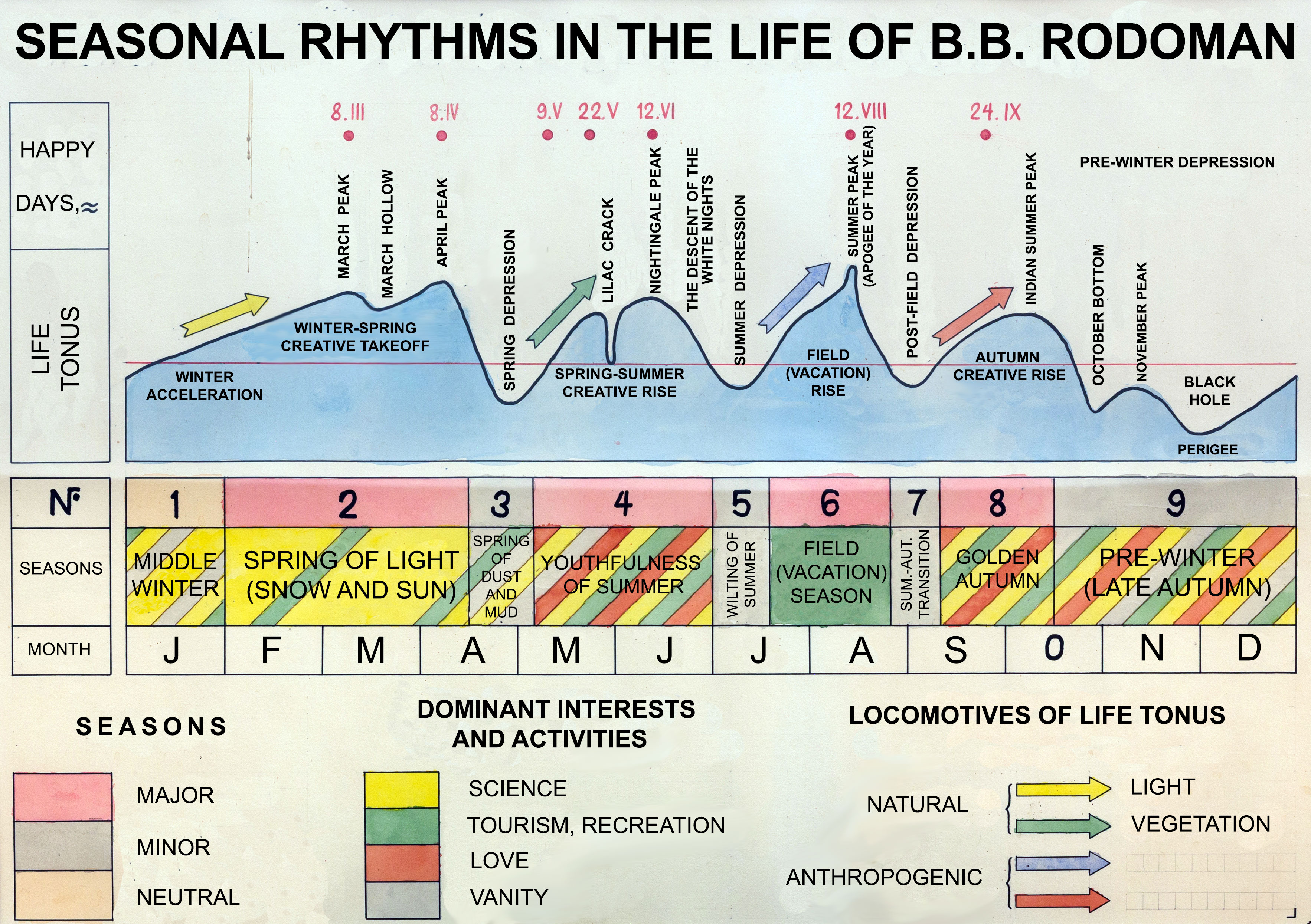
Boris Rodoman, Seasonal Rhythms in my Life: Problems of Theoretical and Humanitarian Geography (Russian Research Institute of Cultural and Natural Heritage, 2013), 24.

21

At the April 2019 conference “Navigation Beyond Vision,” held at HKW in Berlin and organized by e-flux, HKW, and the Harun Farocki Institute (which gave rise to this issue of e-flux journal), Kodwo Eshun shrewdly pointed out this peculiarity of Rodoman’s cartoids. He also compared them to diagrams created by W. E. B. Du Bois for a 1900 exhibition in Paris—diagrams that depicted the social position of African Americans. Compared to photography, which shows its object as a “natural fact,” the diagram portrays the flows of power that construct the subject. The theorist Alexander G. Weheliye recently wrote about this in his “Diagrammatics as Physiognomy: W. E. B. Du Bois’s Graphic Modernities,” CR: The New Centennial Review 15, no. 2 (Fall 2015): 23–58.

22

Rodoman, “My Line in Geography,” 243.

23

See Vladimir Kagansky, Cultural Landscape and Soviet Habitable Space (New Literary Review, 2001).

24

Dmitry Zamyatin, “Meta-geography: On the Way to Co-emplacement,” in Meta-geography: Space – Image – Action, exh. cat. (New Tretyakov Gallery, 2015).

25

Zamyatin, “Meta-geography,” 21. The activity of the Center for Humanitarian Studies, formed and headed by Zamyatin at the Russian Research Institute of Cultural and Natural Heritage, was important in this process between 2004 and 2013, as were several meta-geographical research expeditions carried out by Zamyatin jointly with the Vasiliy Golovanov, Andrey Baldin, and Rustam Rakhmatullin. It can be argued that in the 1990s and 2000s, it was this circle that developed the postmodernist understanding of meta-geography as an “images of space and the space of images.”

26

Zamyatin, “Meta-geography,” 27.

27

In 2015–16, Kirill Svetlyakov, Dmitry Zamyatin, and myself mounted the exhibition “Meta-geography” at the New Tretyakov Gallery in Moscow. This exhibition understood meta-geography as an interdisciplinary tool for navigating representations of space in art, science, and everyday life.

28

Martin W. Lewis and Kären Wigen, The Myth of Continents: A Critique of Metageography (University of California Press, 1997); Xavier Oliveras Gonzáles, Deny Anarchic Spaces and Places: An Anarchist Critique of Mosaic-Statist Metageography (The Anarchist Library, 2010) .

Category
Land & territory
Subject
Optics & Perception, Geography, Maps, Soviet Union
Return to Issue #101

Nikolay Smirnov works as an artist, geographer, curator, and researcher.

Advertisement
Subscribe

e-flux announcements are emailed press releases for art exhibitions from all over the world.

Agenda delivers news from galleries, art spaces, and publications, while Criticism publishes reviews of exhibitions and books.

Architecture announcements cover current architecture and design projects, symposia, exhibitions, and publications from all over the world.

Film announcements are newsletters about screenings, film festivals, and exhibitions of moving image.

Education announces academic employment opportunities, calls for applications, symposia, publications, exhibitions, and educational programs.

Sign up to receive information about events organized by e-flux at e-flux Screening Room, Bar Laika, or elsewhere.

I have read e-flux’s privacy policy and agree that e-flux may send me announcements to the email address entered above and that my data will be processed for this purpose in accordance with e-flux’s privacy policy*

Thank you for your interest in e-flux. Check your inbox to confirm your subscription.