


With its iconic archipelago of polders, clear-cut boundaries between rural and urban, straightened or purposely bent waterways, and highly efficient yet intensive swaths of agricultural land, the Dutch landscape is often used as an example of strong spatial planning practice. The historical desire to turn uninhabitable land into productive cities with fertile hinterlands—often in a landscape form called a “polder”—forced hostile communities to bury the hatchet and collaborate to fight a common enemy: water. Nowadays, this history has grown into a political model inherent to contemporary Dutch governance, a decision-making practice called polderen. According to the poldermodel, all relevant stakeholders deserve a spot at the table, and everything should be done to reach a consensus with all parties before decisions are made.
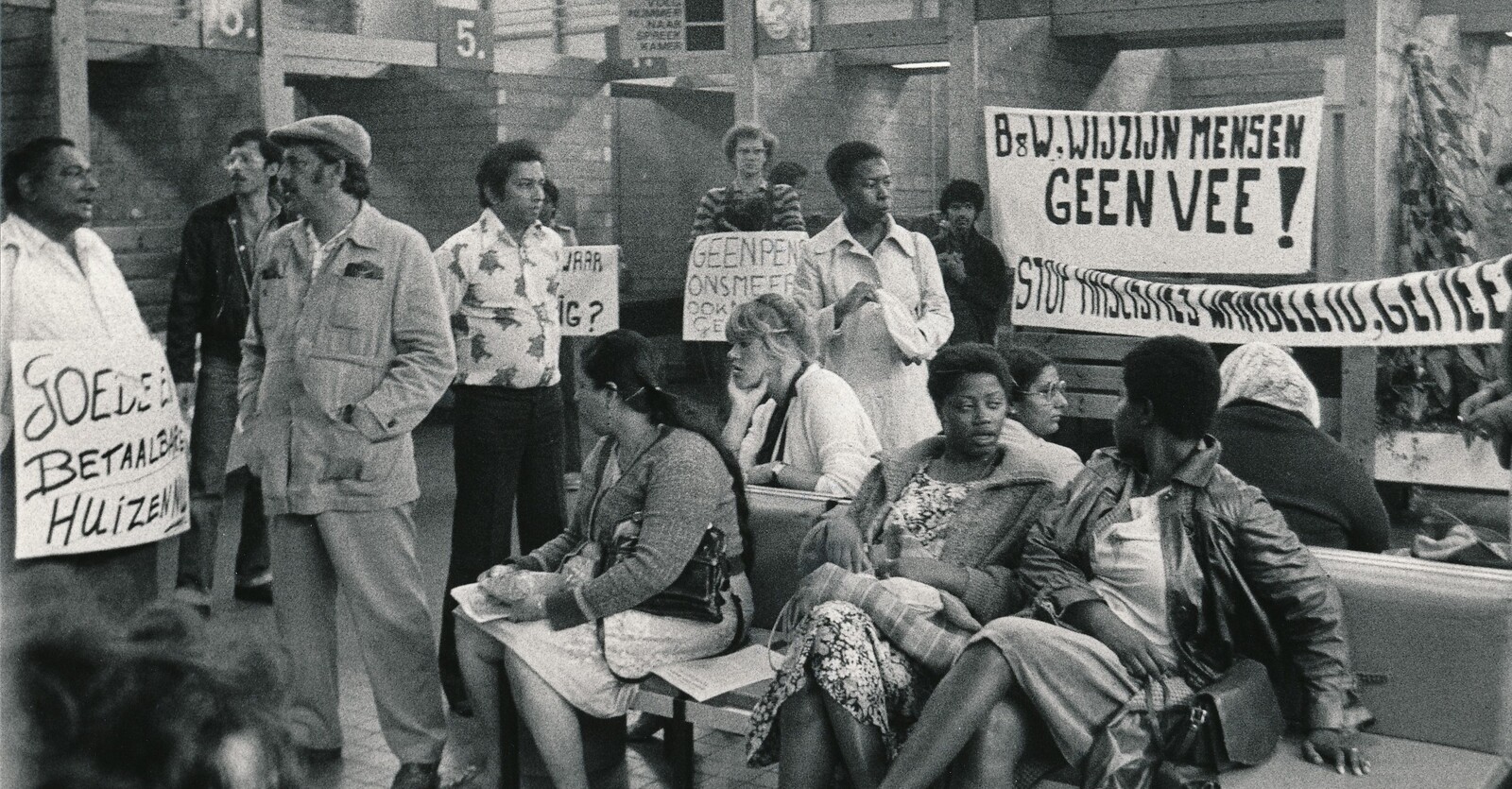
The Netherlands is currently facing numerous spatial challenges, such as where to generate renewable energy, how to supply housing that suits everyone’s needs, how to create a more sustainable agricultural sector, and how to mitigate and adapt to climate change. These challenges are all competing for the same space. And despite the arguably noble practice of polderen, the drastic changes that have been made to the Dutch landscape over the last centuries have not always taken place after reaching consensus with all stakeholders. Instead, some groups were not recognized as stakeholders, or were simply not given a spot at the table. Throughout time, the benefits and burdens of these spatial changes have not always been carefully distributed.


View from a polder field of the village of Jisp, a former whaling town, which was built through ribbon development. Photo: Claudia Rot.
The Beemster
The Beemster was a large lake in the west of the Netherlands that connected to the Zuiderzee, which was itself connected to the North Sea. This made the surrounding area, including the quickly expanding city of Amsterdam, vulnerable to floods. A plan was made in the early 1600s to drain the lake, in order to secure more agricultural land, increase food security in Amsterdam, and improve flood resilience of the surrounding area. The rights to drain the lake were granted by the State to the “Beemster Company,” which consisted not only of landowners and aristocrats from the Holland province, but also Amsterdam merchants who had seen their riches grow rapidly after the establishment of the East India Company in 1602.1 The draining process took place from 1607–1612 and resulted in a large area that could be prepared for productive use.
While reducing the entire region’s flood risk, draining the lake also added to the total surface of available agricultural land. For farmers, access to fertile land has always been a challenge in the Netherlands. By the time that the Beemster was made available for settlement, smaller polder experiments nearby had proven that this new type of land would become fertile enough to sustain a family within a few decades.2 Thus, many farmers who had been working someone else’s land were eager to build their own by renting land from the landowning merchants. For many, this was their best chance at better life, regardless of whether they could trust the dikes to keep water out, or their landlords to allow them to stay.3


Polder windmill in the Wormer- en Jisperveld, the largest continuous peat landscape in Western Europe. These small windmills are used for water drainage at the local level, pumping water from the fields to bigger canals. Photo: Claudia Rot.
The growth and development of this new land was backed, both politically and financially, by the power of Amsterdam. This was done through the agency of the water boards (waterschappen), or regional governing entities in Holland responsible for managing surface water within a certain area first established in the twelfth century.4 Bodies of water are always part of a larger hydraulic system, including runoff and absorption, streams, rivers, lakes, and oceans. Collectively governing over different areas of water means that any decision effects everyone, to varying degrees of intensity. When one water board decides about the water level in their jurisdiction, the level of those nearby is affected as well.
The Beemster, which was once a lake, was now only indirectly connected to surrounding waters by a dike and a system of sluices. And given that the water table of the polder was lower than the surrounding land, the Beemster had to keep its land dry. Dozens of canals running throughout the polder managed the presence of the water table on the new land. These canals worked with a system of pumps, which were designed to empty water out into its immediate surroundings.5 Soon after its establishment, the Beemster water board received a concession from surrounding jurisdictions.6 The Beemster would always be allowed to pump water, be it out of or into the polder. During dry summers, the Beemster would drain water from its surroundings, and during wet winter months, the Beemster would pump so much water out into the surroundings that land would become too soggy to graze cattle.7 In order to ensure agricultural output from the Beemster, the productivity of land surrounding the polder, and the livelihoods of its people, was sacrificed.


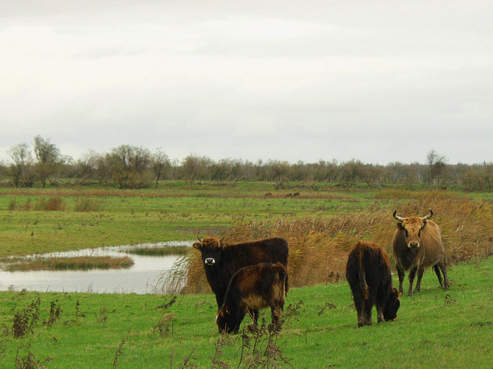
Cows grazing the fields in the Wormer- en Jisperveld. The low nutrient levels in the peat soil are not suitable for crop farming, but are still suitable for cattle. Photo: Claudia Rot.
Closing the Sea
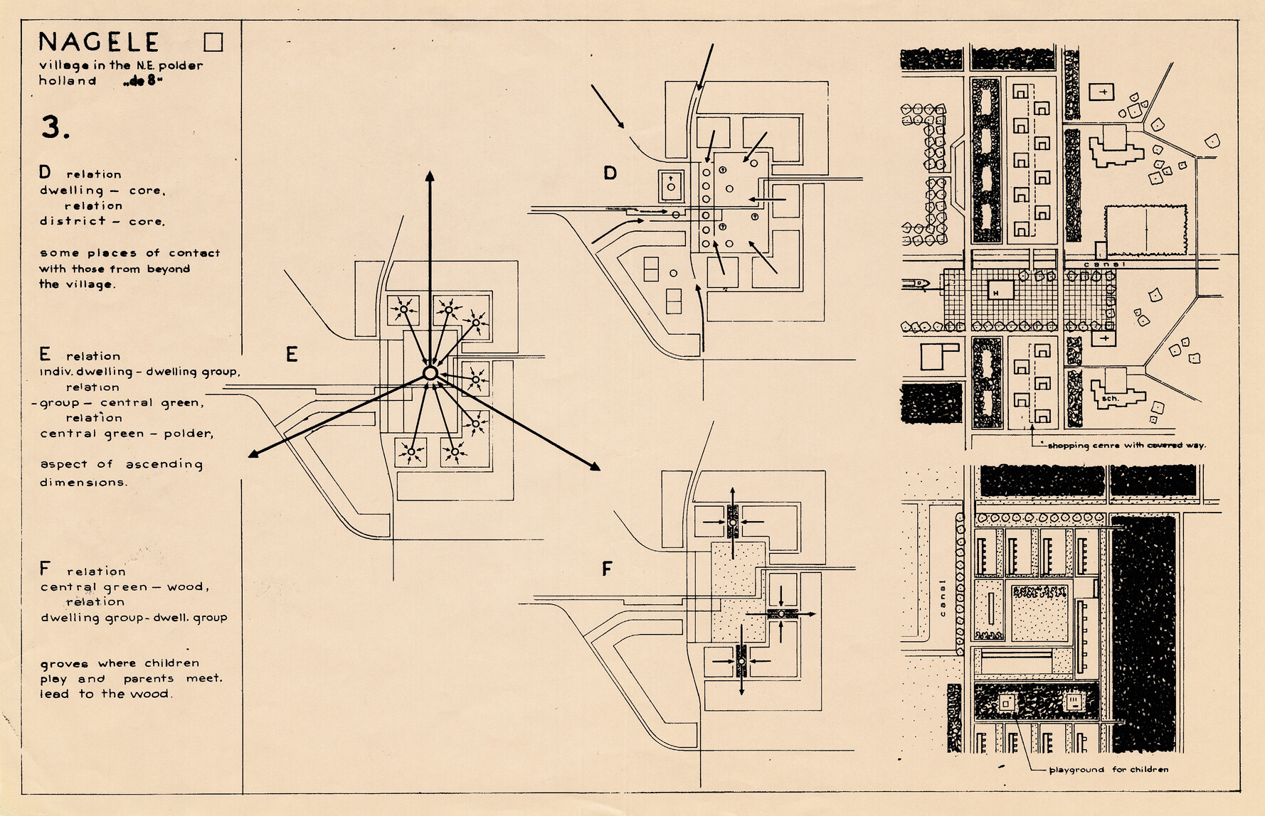
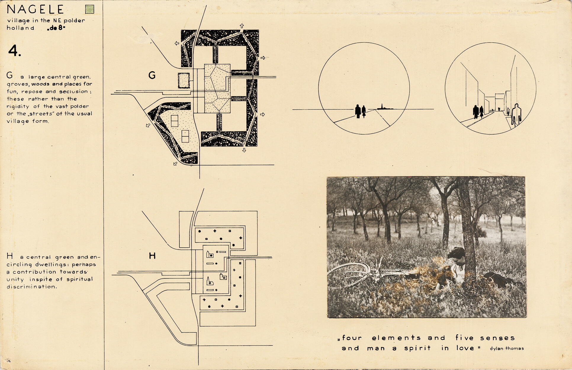
Twentieth-century land reclamation projects in the Netherlands have also been the largest, many times the size of the Beemster polder. The most recent polders were not reclaimed from lakes, but from the sea itself. Wieringermeer (1927–1934) and Flevoland (1942–1968) together created more than 1,600 square kilometers of land, increasing the landmass of the Netherlands by five percent. But with these two polders, the Dutch were not just designing land; they were designing their future society. Entire cities, towns, and agricultural systems were designed with incredible precision, even down to the type of people who would live on it.8 During this time, pillarization—the process of societal segregation based on religious and political beliefs—had reached its most stratified point, encompassing aspects of social life including schools, sports clubs, and cafes. When selecting pioneers for the new polders, then, the government ensured each town would have a “representative mix.”9 In certain instances on the polders, modern architects were given freedom in designing this ideal society. Nagele, for instance, was designed by Aldo van Eyck, Gerrit Rietveld, Cornelis van Eesteren, and Mien Ruys.10
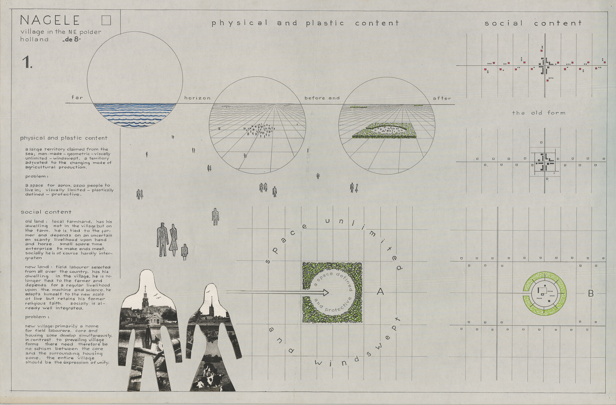
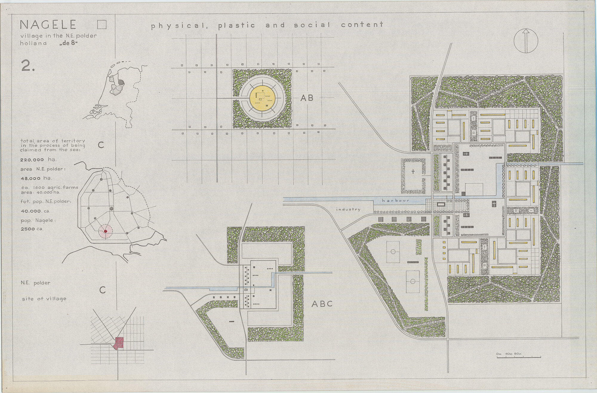
The government ran extensive and highly competitive selection procedures for who could live on the new land. Farmers were chosen because of their physical health, knowledge about agriculture, and sense of community. Only married couples who already came from large farms were allowed to take a lease from the government. The chances for farmworkers to acquire their own farm on the new land were very slim.11 Sociologists and anthropologists at the time hypothesized that a selection of the strongest families in the country would ensure the development of an ideal and strong society for generations to come. This eugenical reasoning was so explicit that during the occupation of the Netherlands in World War II, the German occupiers did not interfere with the development of the polders. Instead, they observed and studied its results for the repopulation of Central and Eastern Europe as part of their Generalplan Ost.12
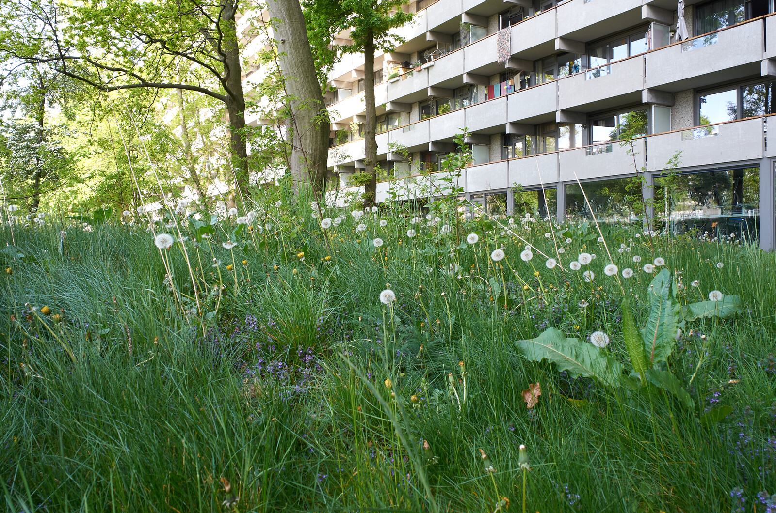
With the Wieringermeer and Flevoland, the Dutch sought to create a highly efficient agricultural landscape. In order to do this, they presumed, they would need hard-working farmers. But by the time the first plots of land became inhabitable, years after the projects began, agriculture itself had changed. Its mechanization, which started only a few years after the first farms were built in Wieringermeer and Flevoland, needed a very different kind of farm work—and workers—than when the polders—and its societies—were first designed. As a result, many new towns never reached their projected size. Their service costs were already high, given the multiplicity of social institutions needed due to pillarization, and with smaller populations, the society that came about increasingly diverged from the ideals originally held by its planners. In the early 2000s, the government allowed farmers to buy the land that they had been leasing until then, giving them more freedom to speculate on its price and use it for other purposes than farming.13 In the Wieringermeer, this has drastically changed the face of the landscape, and has led to a large increase in greenhouse farming and the construction of large data centers for multinational corporations.14


Summer hay collection in the Wormer- en Jisperveld. Asides from cattle grazing, nutrient poor peat soils can be used to cultivate grass and hay as animal feed. Photo: Claudia Rot.
Sacrifices for Efficiency
Despite the varied outcomes for new communities on reclaimed land, the agricultural yield of new polders cannot be disputed. After World War II and the mechanization of farming, the Netherlands began to overproduce, to the extent that it has become the world’s third largest net exporter of agricultural products; after Brazil and Argentina, but with only a fraction of the land.15 These high yields come at high environmental costs. Overproduction has led to high levels of nitrogen deposition and a degradation of biodiversity in natural areas. The reclamation of land and the alteration of the landscape has also come at high societal and cultural costs.
While families were being selected from all over the country to move to new lands, communities that were located not on but close to the new land saw their livelihoods slipping away. When the Zuiderzee was closed off from the North Sea with a thirty-two-kilometer-long dike in 1932, the water in the former Zuiderzee lost its connection to seawater and slowly started to become brackish.16 Most fish species in the Zuiderzee disappeared over time, taking away the main source of food and income for these fishing towns. But then the water was taken away altogether, when large swaths of the Zuiderzee were reclaimed and became Flevoland. Many seaside or lakeside towns with formerly flourishing fishing economies found themselves becoming landlocked over the course of a few years. There are towns in the middle of provinces that show histories of whaling, shipbuilding, or fishing with no current access to large bodies of water.17


The Diemerzeedijk stretches between the east of Amsterdam and the city of Muiden. Photo: Claudia Rot.
Conclusion
The Dutch have a history of highly efficient land use, reclaiming land from lakes and seas, and turning forests or sandy soils into arable land. But they also have just as consistent a history of sacrificing land and communities’ livelihoods (not to mention the expropriations, extractions, and accumulations the Dutch have made in other parts of the world).18 These decisions are always argued to be “for the greater good” of the entire country. But it is clear that this “good” is not distributed equally.19
When facing contemporary spatial challenges, the Netherlands should look back to its past and try not to repeat the mistakes that have been continuously made during its more than 400-year history of land reclamation. The technical expertise is available to address contemporary spatial challenges, but these challenges cannot solely be approached from a technocratic perspective. We should strive for a new approach to polderen: a planning and design practice that expands the scope of its work from the “greater good” to a “greater we.”
Wouter Reh, Clemens M. Steenbergen, Diederik Aten, and Willem Messchaert, Zee van Land: de droogmakerij als atlas van de Hollandse landschapsarchitectuur (Wormer: Stichting Uitgeverij Noord-Holland, 2005).
Ibid. See also Auke Van der Woud, Het Landschap, De Mensen: Nederland 1850-1940 (Amsterdam: Uitgeverij Prometheus, 2020).
Van der Woud, Het Landschap, De Mensen (2020).
Ibid.
Johan Van Veen, Dredge Drain Reclaim: The Art of a Nation (The Hague: Nijhoff, 1962).
Reh, Steenbergen, Aten, and Messchaert, Zee van Land (2005).
Ibid.
Ibid.
Eva Vriend, Het Nieuwe Land: Het verhaal van een polder die perfect moest zijn (Amsterdam: Balans, 2013).
Zef Hemel and Vincent van Rossem, Nagele: een collectief ontwerp 1947-1957 (Amsterdam: Nederlands Documentatiecentrum voor de Bouwkunst, 1984).
Vriend, Het Nieuwe Land (2013).
Ibid.
Marten Kuijpers, “Van ijsbergsla naar data: Grondpolitiek in de polder,” Archined (March 8, 2021), ➝.
Ibid.
Van der Woud, Het Landschap, De Mensen (2020).
Van Veen, Dredge Drain Reclaim (1962).
Ibid.
The connection between Dutch capitalism and environmental resource extraction throughout time has been discussed by Jason W. Moore, who based his research on the work of Charles Wilson. Jason W. Moore, “‘Amsterdam is standing on Norway’ part II: The global North Atlantic in the ecological revolution of the long seventeenth century,” Journal of Agrarian Change 10, no. 2 (2010): 188–227. Charles H. Wilson, The Dutch Republic and the Civilization of the Seventeenth Century (New York: McGraw-Hill, 1968).
The concept of sacrifice zones on which this argumentation is based has been thoroughly explored by Steve Lerner in case studies of toxic chemical pollution in the United States. Steve Lerner, Sacrifice Zones: The Front Lines of Toxic Chemical Exposure in the United States (Cambridge, MA: MIT Press, 2012).
Where is Here? is a collaboration between Het Nieuwe Instituut and e-flux Architecture following Who is We?, the Dutch pavilion at 2021 Venice Architecture Biennale.